|
|
 |
|
|
|
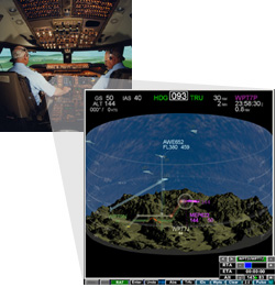 Cockpit Displays of Traffic Information (CDTI) present surveillance information about the surrounding traffic to the flight crew. The information presented includes the relative positions of other aircraft and other traffic information (e.g., track, ground speed, etc.) needed to help the crew maintain a high level of traffic awareness and to allow them to evaluate automated resolutions. Cockpit Displays of Traffic Information (CDTI) present surveillance information about the surrounding traffic to the flight crew. The information presented includes the relative positions of other aircraft and other traffic information (e.g., track, ground speed, etc.) needed to help the crew maintain a high level of traffic awareness and to allow them to evaluate automated resolutions.
A further goal of the CDTI is to provide additional information that will help crews in all their decision making in relation to traffic. It is envisioned that in Free Flight, flight crews will be able to help specify or design conflict resolutions, not just verify/evaluate automated ones. A crew armed with the right tools may be able to manage or oversee how resolutions are coordinated with other aircraft and with air traffic controllers. This requires that the tools provide (1) intent information, (2) alert status information, (3) the ability to create resolutions, (4) the ability to share this information with involved parties, and (5) the means to implement these resolutions.
This display is typically used in conjunction with the Boeing 747-400 Level D flight simulator at the NASA Ames Research Center but it can also be used in stand-alone mode. Some of the controls for the display were provided as hard controls in the simulator and may thus not be available through the touchpad or mouse when operating is stand-alone mode. The group is currently adding features to create, what might be called, an advanced cockpit situation display.
Implementing 3D Visualization and the Advanced Cockpit Situation Display (CSD)
The FDDRL cockpit situation display (CSD) supports both traditional 2D and advanced 3D visualization modes. In its most fundamental configuration the CSD emulates a standard 2D glass cockpit navigation display. However, both the 2D and the 3D modes can provide any or all of a rich set of symbologies, functionalities, and tools that have been designed to:
1) depict the 4D interrelationship of traffic, terrain, and weather within the airspace volume
2) provide a graphical user interface (GUI) to the Flight Management System.
The latest graphics technologies are used to enhance immersion and situation awareness, allowing the flight crew to move effortlessly and smoothly between 2D and 3D views. Specifically, the display is based on a cylindrical container-like metaphor, and the flight crew can simply rotate this cylindrical space into various orientations for preferred viewing angles.
In addition to manually rotating the display volume, the flight crew is given several pre-set buttons that are pre-configured to various canonical vantage points, or which the user can configure to user-preferred vantage points. Panning, zooming, anisotropic scaling, and several selectable viewing modes are morph-animated between transitions to maximize continuous orientation awareness. Environmental visualizations such as weather objects and terrain features not only provide useful positional and hazard cues along a proposed route, but aid in sustaining the immersive experience.
 |
 |
 |
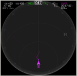
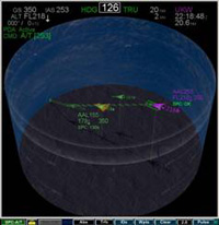
| Top-Down CDTI Orientation |
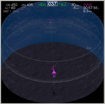
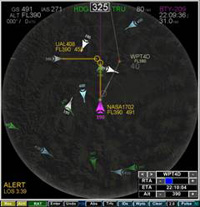
3-D perspective CDTI Orientation |
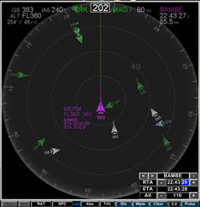
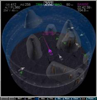
Profile CDTI Orientation |
Some of the key enabling tools for enhancing pilot performance that have been implemented on the CSD include:
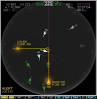 Conflict Detection and Resolution (CD&R) Conflict Detection and Resolution (CD&R)
The original detection component of CD&R, developed at MIT, has been enhanced to provide both deterministic and probabilistic alerting. CSD alerts are depicted for strategic conflict detection as opposed to tactical conflict detection. The alerting logic detects upcoming conflicts (or losses of separation) based on an algorithm which takes into account the aircraft intent information and/or aircraft state information (current heading, altitude, speed). Conflict resolution responsibility is determined by AI-based rules-of-the-road, which unambiguously assign conflict-resolution responsibility to a single aircraft. The automated resolution component is derived from a geometric algorithm developed at NASA Ames. This but which has been heavily modified to accommodate FMS information and constraints to calculate speed, altitude, and lateral maneuvers.
In the near future, Heinz Herzberger's Advanced Airspace Concept Conflict Resolution Logic will be added to the existing CD&R tool. The algorithm of choice will be configurable at runtime. While both algorithms compute resolution maneuvers based on geometric analysis, they differ primarily in how the burdened aircraft (the aircraft burdened to resolve the conflict) is selected. The first and original resolution as described above is based on rules-of-the-road and is ownship-centric. The second resolution algorithm considers all possible maneuvers among all aircraft involved in the conflict. Burdening is then assigned to the aircraft that has the optimalsolution available, regardless of the rules-of-the-road. This is therefore a multi-aircraft solution driven algorithm. Both algorithms will fully support the CSD Route Assessment Tool (RAT), described in the following section.
|
 Route Assessment Tool Route Assessment Tool
The Route Assessment Tool (RAT) provides the ability to create and visualize in-flight route modifications, submit proposed route modifications to ATC, receive route modifications from ATC, and execute any of these modifications depending on flight status.
The planning and implementation of these flight plan modification possibilities are subject to provisional alerting and are made available for:
1) strategic conflict resolution
2) RTA requirements
3) weather avoidance
4) direct route efficiency
5) dynamic Special Use Airspace (SUA) avoidance
6) terrain avoidance.
|
 Required-Time-of-Arrival (RTA) Tool Required-Time-of-Arrival (RTA) Tool
The Required-Time-of-Arrival (RTA) algorithm generates speed advisories for meeting an assigned RTA at the metering gate. The RTA is set using the RAT, which attempts to assign airspeeds that achieve this RTA. As with all the other CSD tools, the RTA tool was designed for intuitive interaction.
|
 Spacing Tool Spacing Tool
The SpacingTool allows for self-spacing behind a designated lead aircraft (e.g., maintain 90 seconds behind aircraft XYZ). The spacing tool requires an input of the assigned en trail spacing value while algorithms work to adjust Ownship's speed in order to maintain the required interval. While the tool is active, the pilot is provided with updated visual information regarding the current spacing status.
|
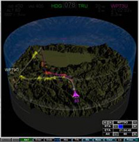 3D Terrain Display 3D Terrain Display
The 3D Terrain Display provides location and hazard cues to pilots. Topographic information including bodies of water are presented in a three dimensional format that is proportional to vertical scaling. An uncluttered format is also available that projects the surface detail onto a flat plane. The database consists of high resolution mapping (down to 30 meter detail) of the continental US. Flight planning incorporates real-time interactive hazard detection of terrain by highlighting proximal regions of terrain along the proposed path.
|
 2D/3D Weather Display 2D/3D Weather Display
Pilot-selectable 2-D and 3-D depictions of weather objects and terrain features are integrated into the display, and allow intuitive and direct evaluation of the relationship of these hazards to the intended route. A weather data collection and delivery system was developed to meet the needs of the FDDRL for providing realistic weather scenarios in its simulations. It is comprised of three subsystems. The Wx Collection subsystem acquires real-world weather data from NOAA and NWS portals, and correlates and stores them. The Wx Scenario Generator accesses the data repository and provides for searching and viewing/editing capabilities to create a suitable weather environment in a scenario. The Wx Server coordinates scenario access functions via network commands or a web interface from connected clients, and distributes the data. The FDDRL CSD is the first such client, rendering a 3D stylized representation of the weather.
|
|
|